Viæ Regiæ - a new public history project
Published: 24th February 2021

Dr Stephen Gadd
@ViaeRegiae
History was the first subject Stephen dropped at school, because it was boring (Kings and Queens, blah blah blah) and they wouldn't let him drop P.E.. With a degree in Engineering, Stephen travelled the world for 30 years as an opera singer before gaining his PhD in 2019 for a study of Early Modern river navigation. He is interested in transport history more generally, and in particular in the economic and infrastructural changes that derived (in part) from a reformation in property rights that began in the 1530s.
This project has the grand ambition of working with a national network of local volunteers to try to detect early signs of industrial development in England and Wales between 1530 and 1680.
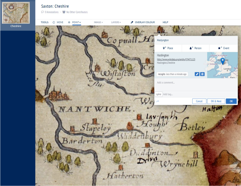
In the process, our volunteers will produce richly-annotated editions of the county maps produced by Christopher Saxton (c.1540-c.1610) and John Speed (c.1551-1629), and of the English and Welsh Itineraries of John Leland (c.1503-1552). They will also survey a vast array of documentary sources in both national and local archives, looking for indicators of changes in the economic prosperity and industrial output of settlements and in the viability of routes to shifting markets by both land and river transport. Place-names identified on maps and other original documents will be linked to points layered onto a modern map, enabling a visualisation of the evolving interdependency of centres of production and consumption.
It is already evident that recovery from the social and demographic disruption of monastic Dissolution, recorded in John Leland’s Itineraries, resulted in a drive led by Lord Burghley to assess a changing national economic landscape through the commission of maps and surveys of ports and other coastal settlements. It is also evident that by the 1620s, the increasing use of roads (a term then newly-applied to highways) by vehicles of increasing size and load-bearing capacity led to increasing demands for their repair. Increased mobility during the Civil War caused an increase in demand for maps and travellers’ guides, and by the late 1660s John Ogilby was surveying for what would become in 1675 the first published road map of England and Wales. His one hundred strip maps record not only the ‘principal routes’ but also a great deal of detail about agriculture, enclosure, windmills, and bridges. Although he recorded no roads, Saxton had in effect conducted the first national survey of bridges, with more than eleven hundred recorded on his county maps. Having checked their geolocation in an early phase of the project, volunteers undertaking later work on Ogilby’s maps may reveal something of the construction of new bridges to accommodate a realignment of road networks meeting changing transportation demands.
The collaborative collection of large datasets relies not only on human volunteers but also on a dependable technical framework. This framework delivers the project’s web site and wiki (a community-curated knowledge exchange), and also the software tools such as Recogito for identifying places and their locations within existing ‘gazetteers’, authoritative directories of place-names. It will also be the repository for the project’s own Gazetteer of Early Modern England & Wales, affectionately known as EMEW. Following standards developed by the Pelagios Network and the World Historical Gazetteer, EMEW will record spatial and temporal attributes for settlements and transport links, and will link those features to related features in a world of other information banks.
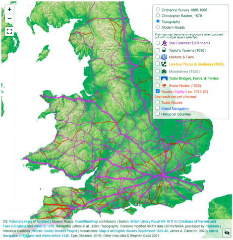
EMEW will be the engine behind the development of an interactive economic map of Early Modern England and Wales, the prototype of which can be seen here. Features shown on the map will link directly to images of the source material and to linked lists of other related sources.
Under the leadership of Colin Greenstreet (also known for MarineLives) the project will recruit teams of volunteers on rolling 10-week cycles, each focussing on a different area of interest. Despite launching only at the beginning of February, the project already has a full complement of volunteers for its first cycle, working on Saxton’s maps and Leland’s Welsh Itineraries, and on populating the project’s wiki with lists, county by county, of relevant archival sources. Apart from specifically local sources, these will also include any surviving Quarter Sessions records of highways and the licensing of inns, together with probate material covering the wills and inventories of individuals involved in manufacture, trade, and transport.
The first cohort of volunteers includes genealogists, librarians, history students, retirees, archivists, academics, amateur historians, data experts, and software engineers. The next cohort could include absolutely anyone interested in contributing to collective knowledge while learning and practising new skills such as palaeography, transcription, and the use of online teamworking tools.
Interested in volunteering for this exciting project? Follow @ViaeRegiae on Twitter and then head straight to ViaeRegiae.org!
Dr Stephen Gadd
Co-leader of Viæ Regiæ
The views and opinions expressed in this blog are those of the author and do not necessarily reflect the official policy or position of the British Association for Local History (BALH). Any content provided by our contributors is of their own opinion and is not intended to malign any individual, group, organisation, or entity.